
28 Nov 2023
Safe Inspection of Tall Buildings with Autonomous Aerial Mapping
Inspection of tall buildings is a major challenge for facilities owners. Oxford Robotics Institute has developed an entirely autonomous system for mapping tall buildings.

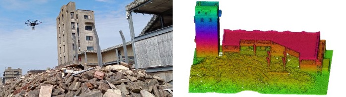
The Osprey autonomy system mapping a training facility at the Fire Service College
Inspection of tall buildings is a major challenge for facility owners. Accessing those sites with people typically requires complex planning and can be very dangerous. For example, this article described a simple rope tangle trapping an engineer on a 93-foot lighthouse.
Oxford Robotics Institute has developed an entirely autonomous system to more safely address this issue. The system can map tall buildings (up to nine floors) while ensuring 3D map coverage.
Osprey is an autonomous aerial mapping system which showcases multiple years of research by the Dynamic Robot Systems (DRS) and Estimation, Search, and Planning (ESP) groups at ORI. At the core of the system is a DJI M600 drone carrying a custom autonomy payload developed at ORI called Frontier. Frontier combines a computer, a 3D LiDAR scanner, several HD cameras, and an IMU.
The autonomy system brings together state-of-the-art approaches for odometry, mapping, mission and motion planning. Osprey uses VILENS odometry (David Wisth, Marco Camurri and Maurice Fallon) and VILENS-SLAM (Maurice Fallon, David Wisth and Lintong Zhang) to map its environment.
To ensure complete coverage, the map is passed to the SEE mission planner (Rowan Border and Jonathan Gammell) and AIT* for motion planning (Marlin Strub and Jonathan Gammell) to plan routes around buildings. As battery capacity is limited, Osprey needs to relocalize between battery swaps to continue extending its map. This is achieved using an implementation of ScanContext (Giseop Kim, Sunwook Choi and Ayoung Kim of SNU, Korea).
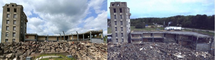
Field demonstrations with Osprey were conducted at the Fire Service College (FSC), a training centre for emergency responders about an hour from Oxford, where the system autonomously captured highly complete maps of three large industrial sites with heights up to nine floors. Detailed colour maps were created in post processing, including photorealistic renderings using SiLVR (Yifu Tao, Yash Bhalgat, Nived Chebrolu and Maurice Fallon), a NeRF-based reconstruction approach.
The researchers working on the system integration were Rowan Border, Nived Chebrolu, Yifu Tao, Jonathan D. Gammell, and Maurice Fallon. The Frontier sensor payload and mount for the M600 drone was built by ORI's hardware engineering team, with special thanks to Wayne Tubby, Matt Towlson, and Arundathi Shanthini.
For more information please contact Prof. Maurice Fallon: mfallon@robots.ox.ac.uk.
A video of Osprey in action is shown below and a preprint of a paper, which has been submitted to the Field Robotics journal, can be found here.


